


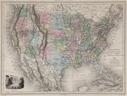
Alexandre Vuillemin. “États-Unis.” From Géographie Universelle.
Paris: J. Migeon, ca. 1872. 10 3/4 x 14 3/4. Engraving by H. Nyon. Original hand color. With vignette of Washington, D.C. Very good condition.
A handsome, original antique map of the United States from J. Migeon’s French atlas. This map was drawn by Alexandre Vuillemin, who was a member of the Société de Géographie de Paris. It is carefully drawn and precisely engraved, the hand coloring adding a decorative appeal, each state and territory indicated with a contrasting shade. The transportation network in the country is delineated and much of the known topography. Indian tribes, rivers, settlements and railroads are indicated throughout.
This map indicates Yellowstone National Park which was created in 1872. However, Utah still retains the northeast portion which it ceded to Wyoming in 1868. Note: Montana Territory was accidentally not fully colored to reflect the actual size of the territory due to its faintly engraved western borders.
 %20%0A%20%0Ahttps://philaprintshop.com/products/vuillemin-alexandre-etats-unis-from-geographie-universelle %20%0A%20%0AVuillemin,%20Alexandre%20%20%E2%80%9C%C3%89tats-Unis.%E2%80%9D%20%20From%20%22G%C3%A9ographie%20Universelle%22 %20%0A%20%0A//philaprintshop.com/cdn/shop/products/vuilleminusc_1024x1024.jpg?v=1652984472 %20%0A%20%0AAntique Prints, Maps, Drawings, Paintings and Rare Books! %20%0A%20%0AThe Philadelphia Print Shop %20%0A106 E. Lancaster Avenue, Lower Level %20%0AWayne, PA 19087 %20%0A%20%0APhilaPrintShop.com %20%0A@PhiladelphiaPrintShop %20%0A 610 (808) 6165)